A. After finishing a doctorate degree in Science(D.Sc.)at the University of Tokyo in1988, I joined the Geological Survey of Japan (GSJ), Ministry of International Trade and Industry (MITI) that is currently the National Institute of Advanced Industrial Science and Technology (AIST), Ministry of Economy, Trade and Industry (METI), and worked there for slightly less than seven years. In 1994, I moved to the University of Toyama and spent about four years. In 1998, I transferred to the Japan Marine Science and Technology Center (now Japan Agency for Marine-Earth Science and Technology (JAMSTEC), Ministry of Education, Culture, Sports, Science and Technology since 2004)) and served there for 22 years. It has been two years and seven months since I started to work for my current employer, IDEA Consultants, Inc. The careers mentioned above include two years as a faculty member of Texas A&M University in the U.S. from 1990 to 1992 when I was a member of GSJ and two and a half years between 2000 and 2002 as the head of the representative office in the capital city of Washington, D.C. from its inception during my time at JAMSTEC. During my time at GSJ, I seconded to the Science and Technology Agency (STA), where I gained experience as an administrative bureaucrat in the Kasumigaseki area from 1993 to 1994. Although my organization has changed, I have always engaged in oceanographic sciences, mainly in the open sea. I have spent about three years and seven months on board for research voyages, or in other words, living at sea. I have taken on submarine resources for the last ten years. The longest expedition was in Antarctica, which lasted about two and a half months. I went there as part of a petroleum resources survey with MITI. Out of the Seven Seas, I have been to every ocean except the Arctic Ocean.
A. As Managing Executive Officer, I am in charge of the ocean strategy of the Environmental Survey Business Division and am responsible for expanding the company’s ocean-related business. In addition, I am responsible for the smooth and steady execution of existing orders, new business development, and the adoption of research and development projects funded by external budgets. The oceans cover more than 70% of the Earth’s surface, but there are still many unknowns, and my passion is to help elucidate them.
A. We are an integrated consultancy for social infrastructure and environmental conservation. We are engaged in ecological consulting business such as environmental research, environmental chemical analysis, environmental assessment planning, and natural environment maintenance and preservation; construction consulting business such as maintenance and protection of rivers, coasts, ports, fishing ports, roads, bridges, traffic, and urban area planning and design; information systems business; and overseas projects.

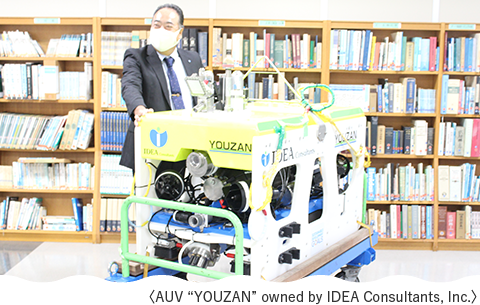
A. AUV stands for Autonomous Underwater Vehicle; an automatic robot autonomously navigates along pre-programmed routes near the seafloor to conduct surveys. The AUV we use is a hovering type. It can operate at depths of up to 2,000 meters and capture 4K video images, allowing for highly accurate identification of organisms. When moving underwater, the AUV can check its position from the ship via a communication system and exchange data by sending commands via Wi-Fi.
The automatic avoidance function detects distance and avoids obstacles, and the boat will return to the starting point on its own, even in tidal currents. However, due to the battery, it can only operate for up to 8 hours. Despite this limitation, it can reliably search for 4 to 5 hours if things are going well, even at a depth of 2,000 meters. In addition, a steel camera attached to the bottom of the unit allows us to take pictures of the seafloor in every nook and cranny so that we can complete the seafloor mapping simultaneously.
A. In December 2021, the Tokyo Metropolitan Government conducted a field survey around Okinotorishima Islands in cooperation with Tokai University. Tokai University requested us to perform an AUV survey of the slope of Okinotorishima Islands as part of our work because of my experience surveying seafloor resources in this area when I was at MITI and JAMSTEC. So, we participated in the voyage with all preparations in place. Still, due to poor sea conditions, the AUV survey and the deep-sea water sampling survey were canceled, which was a great disappointment. It is true that when I learned that the Tokyo Metropolitan Government had issued a call for applications, I applied for the position, strongly hoping for revenge for the December 2021 survey.
A. Although the number of days of voyage and the size of the vessel we can use are limited, we have decided to give priority to a topographic survey, biota identification, and observation of the seafloor that forms the islands, which are indispensable when considering the utilization and conservation of the islands.
We have already conducted the first year’s survey. Although sea conditions were a bit unfavorable at times, and we could not do seafloor observation as scheduled, we did not encounter any typhoons and could conduct all the planned surveys. We are currently analyzing the acquired data and samples and compiling a summary of the origin of Okinotorishima Islands and the biota of the surrounding sea area. We will conduct the field survey in the first and second years of the three-year project. We will decide the details of the voyage plan for the second year, considering the results of the first year, but the essential survey items will remain unchanged, and we will consider what we can do. In the third year, we would like to clarify the geoscientific overview of Okinotorishima Islands and the surrounding waters by summarizing the analysis of samples and data obtained during the first and second-year voyages. This year we were blessed with good sea conditions and were able to take measurements along with those taken last year. We want to survey to clarify the island’s status, what has been done so far and what will be done in the future, which is necessary for utilization and conservation. In addition, we would like to conduct an even more extensive survey of the current situation next year. We want to identify many other things, such as the seafloor surface and the organisms that inhabit it.
A. This survey will provide further information and critical insights for future studies. In addition, the seafloor topography data and biota will provide guidelines for more detailed surveys, which are considered essential in planning specific measures for future utilization and conservation of the island.
A. I have been to Minamitorishima Islands, the easternmost island of Japan. When I heard about last year’s survey of Okinotorishima Islands, I was strongly attracted to it because it sounded like "I have never been there yet" and "it is the southernmost point of Japan."
Okinotorishima Islands is part of 3,000 kilometer Kyushu-Palau Ridge, the volcanic island chain like the Izu-Bonin Islands which sank to the seafloor 30MA-15MA, and the fact that only Okinotorishima Islands is showing its face on the sea surface is exciting from an earth science point of view. Furthermore, it was an emotional experience to see the southernmost Okinotorishima Islands. Both Minamitorishima and Okinotorishima Islands solitary islands in the distant sea, about 2,000 kilometers away from Tokyo, are also Japan’s territory.
A. Despite the limitations of the survey items, a comprehensive academic survey such as this is a rare opportunity for Okinotorishima Islands. Clarifying the origins and biodiversity of Okinotorishima Islands, an administrative district of the Tokyo Metropolitan Government will contribute to the future utilization and conservation of the island. Results will include high-quality images and videos of the waters surrounding the island. These will be presented to the citizens of Tokyo at symposiums and other events hosted by the Tokyo Metropolitan Government, so please look forward to them.
 The official website of the Tokyo Metropolitan Government